Cambridge engineers have used drones, handheld particle sensors and a new modelling framework to measure, map and characterise harmful shipping emission particles at both land and sea. It is the first time that multi-characteristic particle measurements – including lung deposited surface area (LDSA), black carbon, and particle number – have been performed in this way, and it is hoped that this research will inform environmental initiatives and support efforts to clean up the maritime sector.
Peak black carbon and LDSA concentrations at our port-side and hotel balcony locations are comparable to exposure levels in underground mining, depending on the location in the mine, and almost twice as high as airport taxiway personal exposure.
Dr Molly Haugen
Particulate matter (PM) is a harmful pollutant commonly found in emissions. When inhaled, it can cause serious health problems, and it is also known to have a negative impact on the climate. Efforts to regulate the maritime sector have resulted in a call for new knowledge and methods to characterise the evolution of maritime particle emissions dispersing in port areas.
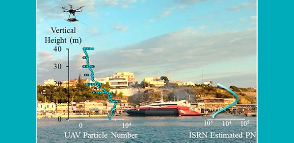
With this in mind, Cambridge researchers ran experiments at the Port of Rafina, in Greece. Land- and drone-based measurements involving five passenger ferries, primarily idling at port, were conducted over a period of seven days in port-side locations (using low-cost, handheld sensor technology), and at-sea at various locations (using a novel instrument set-up mounted on a drone). The drones entered emission plumes, capturing real-time data close to the emission source (passenger ferries). This was achieved in two ways: by slowly ascending and descending through the plume, and by holding a steady position for 10 minutes, at a constant height of 10 metres, approximately 130 metres from ground-based sensors as the ferry accelerated past.
The study has broken new ground; it is the first time that drones have been used for monitoring multiple particle characteristics within plumes in the near field of emissions sources at-sea, in a real-world setting. The findings are reported in the journal Atmospheric Environment.
Experimental observations revealed the differences in particle characteristics. Multiple particle sensors were used to measure more than one particle metric to better understand particle evolution in a maritime plume. These were:
- LDSA – a metric related to the ability of the particle to penetrate the lungs
- Black carbon – a component of PM, the air pollutant
- Particle number – a parameter to measure the number of solid particles emitted by an engine.
Whereas other studies have used drones flying behind ships, none have used more than one particle instrument. By using all three of these characteristics (LDSA, black carbon, and particle number), the researchers can gain valuable information on how the plume is dispersing. This would not have been possible to determine, if only one of the metrics was being measured.
Further still, the research team were able to predict the three-dimensional evolution of particle characteristics by coupling a Gaussian plume dispersion model and a new modelling approach, known as the Incompletely Stirred Reactor Network (ISRN). The aim is to enhance the accuracy of predictive pollutant dispersion methods by taking into account physiochemical transformations of evolving particles within plumes in a computationally affordable way.
From the land-based measurements, researchers found that LDSA averages, which are influenced by particle number and size, increase up to 20 times above background levels as an emission plume progresses downwind. In comparison, black carbon concentrations, which are dominated by mass, are approximately 12 times higher than the background concentration. Particle instruments were positioned in two locations: port-side, and the balcony of the only hotel within the port. The former was five metres above sea-level, 175 metres from the ferry docking area, and adjacent to the only road entering/exiting the port, and the latter was 250 metres from the ferry docking area.
“Interestingly, peak black carbon and LDSA concentrations at our port-side and hotel balcony locations are comparable to exposure levels in underground mining, depending on the location in the mine, and almost twice as high as airport taxiway personal exposure,” said Dr Molly Haugen, Senior Research Associate in Emissions Measurement, and first author of the paper. “These measurements were taken as ferries arrived into the port.”
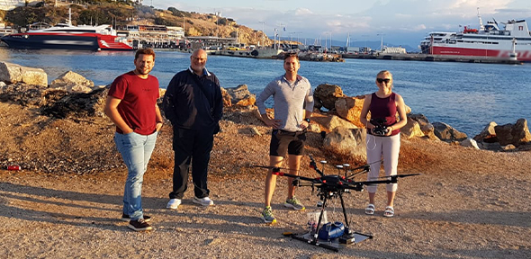
Standing alongside the drone, from left, Dr Savvas Gkantonas, Professor Epaminondas Mastorakos, Professor Adam Boies and Dr Molly Haugen.
The researchers found that the LDSA to black carbon ratio at the hotel balcony location increased by an order of magnitude, meaning that the LDSA rises significantly faster than the black carbon concentration. A similar relationship is shown at the port-side location, with increased LDSA to black carbon ratios when maritime emissions are present, specifically for gas turbine engines1. In both cases, the difference in background particle concentrations from steady traffic in the area is insignificant when maritime emissions are present, say the researchers.
When comparing land- and drone-based particles, particle number and LDSA measurements exhibited greater differences than black carbon relative to the plume’s location. Land-based sensors have approximately 50% lower LDSA and particle number concentrations, whereas black carbon was about equal.
Particle instruments placed in a third land-based location, directly on the dock, showed that the smaller particles emitted in this area are not being captured in black carbon concentrations. This was not the case with LDSA measurements however, which showed a significant impact from maritime emissions.
“These measurements, taken in different sampling locations, should reinforce why dual monitoring of black carbon and LDSA are so imperative,” said Dr Haugen. “The implications of regulating and monitoring black carbon alone, could pose a threat to public health, as these smaller particles being emitted are not captured in black carbon measurements, and have an increased possibility of entering and remaining in exposed lungs. Therefore, maritime vessels could adhere to PM standards while continuing to have high LDSA averages, or smaller particles, leading to unknown health and environmental repercussions.”
Dr Savvas Gkantonas, Research Associate in Numerical Simulations in Turbulent Combustion, and paper co-author, added: “We are interested in developing a model to understand how the aerodynamics of the ferries – and turbulence – affect all kinds of chemical or physical transformations occurring within an exhaust plume. This is not only related to particulate matter emissions but also gaseous pollutants, such as NOx. Eventually, all this knowledge could help improve air quality modelling on a coastal, national or even global scale. However, it is also not hard to imagine a future ‘policing’ application, where a port officer uses a handheld sensor or a drone to measure a pollutant and then plugs the data into a code that identifies an illegal polluter a few kilometres away.”
The researchers are thankful for the support they received for this work. The local authorities (Athens Airport Air Traffic Control, Mayor of Rafina, Coast Guard and Port Authority) embraced this campaign and are keen to continue the dialogue on these measurements.
The research was carried out by the Department of Engineering, University of Cambridge, and the Cambridge Centre for Advanced Research and Education in Singapore (CARES), from a grant issued by the National Research Foundation (NRF), Prime Minister’s Office, Singapore, under its Campus for Research Excellence and Technological Enterprise (CREATE) programme. Special thanks to Mr Peter Benie for leadership with the electronics and software of the sensors.
The project was originally planned to be deployed in Singapore, in 2020, for fieldwork. Due to the COVID-19 pandemic, fieldwork was carried out in Europe instead. However, it is hoped that the Singapore fieldwork plans will be able to recommence in 2023, subject to licenses.
Reference:
Molly J. Haugen; Savvas Gkantonas; Ingrid El Helou; Rohit Pathania; Epaminondas Mastorakos; Adam M. Boies. ‘Measurements and modelling of the three-dimensional near-field dispersion of particulate matter emitted from passenger ships in a port environment.’ Atmospheric Environment (2022). DOI: 10.1016/j.atmosenv.2022.119384
---
1 Whereas the gas turbine-propelled ferries did not have black plumes spewing from their stack pipes, the diesel ferries did – this visible difference was corroborated with the measurements made.
