When a sudden downpour hits the desert what was once dry sand can turn into fast-moving, destructive floodwaters. The best flood detection tools, such as radar satellites, often mistake these sandy landscapes for water. This confusion leaves millions of people in desert regions vulnerable when floods strike.
I am very proud of this work because it is the first step towards making flood mapping more inclusive by not excluding but rather including arid regions. I got an opportunity to present this work at the European Geophysical Union, and it was received very well by those working on the forefront of flood research.
Shagun Garg PhD student
Thanks to a recent study published in Remote Sensing of Environment, PhD student Shagun Garg has found a way to address this and find better ways to detect floods in some of the world’s most overlooked areas.
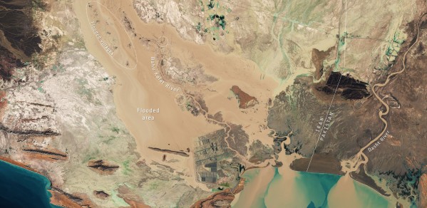
The image above, captured by the Copernicus Sentinel-2 mission, shows the extent of the flooding in the Sistan and Baluchestan province on 13 January 2020. Flooded areas are visible in brown, while the flooded villages are highlighted by dotted circles. Sediment and mud, caused by the heavy rains, can be seen gushing from the Bahu Kalat River, Iran, and Dasht River, Pakistan, into Gwadar Bay. The image can be seen in full here with the option to zoom in.
“When I started this project, I was amazed by how often dry lands were excluded from global flood monitoring studies. Very few studies had focused on this challenge, leaving communities in arid regions at a disadvantage when floods occurred said Shagun Garg – the lead author and a PhD student at Future Infrastructure and Built Environment2 (FIBE2 CDT).
"Floods don’t just happen in rain forests or coastal areas; deserts, too, are at risk. Climate change is making floods more frequent, even in dry regions. But here’s the problem: because sand and flood water can look almost the same from space, current flood detection systems often miss these desert floods. As a result, these areas are left out of global flood maps."
The Sentinel-1 Global Backscatter Model is a dataset that describes the Earth's land surface's C-band radar cross section from 2016–2017. Dry arid lands and water both appear dark in radar imagery, creating a challenge in distinguishing between the two. This similarity leads to mis-classification, making accurate flood detection in desert regions particularly difficult.
European Space Agency Sentinel-1 satellites use radar to scan the Earth, they can “see” the ground even when it’s cloudy or dark. This new research has calculated how to use radar data to tell the difference between dry sand and floodwater more effectively. By combining the amplitude and phase relationship of the radar wave before and after flooding, the authors were able to pinpoint flooded areas that older systems had missed. This approach makes flood detection more accurate by approximately 50%.
 Click the image above to see a larger version the red dots represent the case sites where the Sentinel-1 Global Backscatter Model methodology is developed and tested. Credit: https://gee-community-catalog.org/projects/s1gbm/#license
The proposed methodology was tested during floods in three different desert areas: Iran, Pakistan, and Turkmenistan. In each case, the method successfully mapped the floodwaters where previous methods had failed. For example, after a dam break in Turkmenistan region, radar maps revealed the full extent of the flooding. This can help authorities understand the scale of the disaster, relief planning and evacuation.
With the growing number of satellites in orbit and continuous improvements in their resolution, the Earth’s surface can be observed in more detail than ever before. Combined with advancements in computing power, these satellite images can be processed rapidly, providing quicker and more accurate data during disasters.
Over the past decades, satellites have become essential tools in flood risk and their potential continues to expand. This research is a crucial step in that direction, offering a more inclusive approach to flood mapping, particularly in regions that were previously left out. By paving the way for global flood monitoring, this work has the potential to greatly improve disaster preparedness and response in vulnerable areas.
Shagun said, “I am very proud of this work because it is the first step towards making flood mapping more inclusive by not excluding but rather including arid regions. I got an opportunity to present this work at the European Geophysical Union, and it was received very well by those working on the forefront of flood research.”
Shagun Garg is a PhD student at EPSRC Centre for Doctoral Training in Future Infrastructure and Built Environment2 (FIBE2 CDT). Shagun is working on understanding the effectiveness of nature-based solutions for hydrometeorological hazards using remote sensing. He is supervised by Dr Sakthy Selvakumaran and Dr. Edoardo Borgomeo at the Department of Engineering, University of Cambridge.
